The Pamir Highway: a road born of the Great Game and the world's loneliest crossing
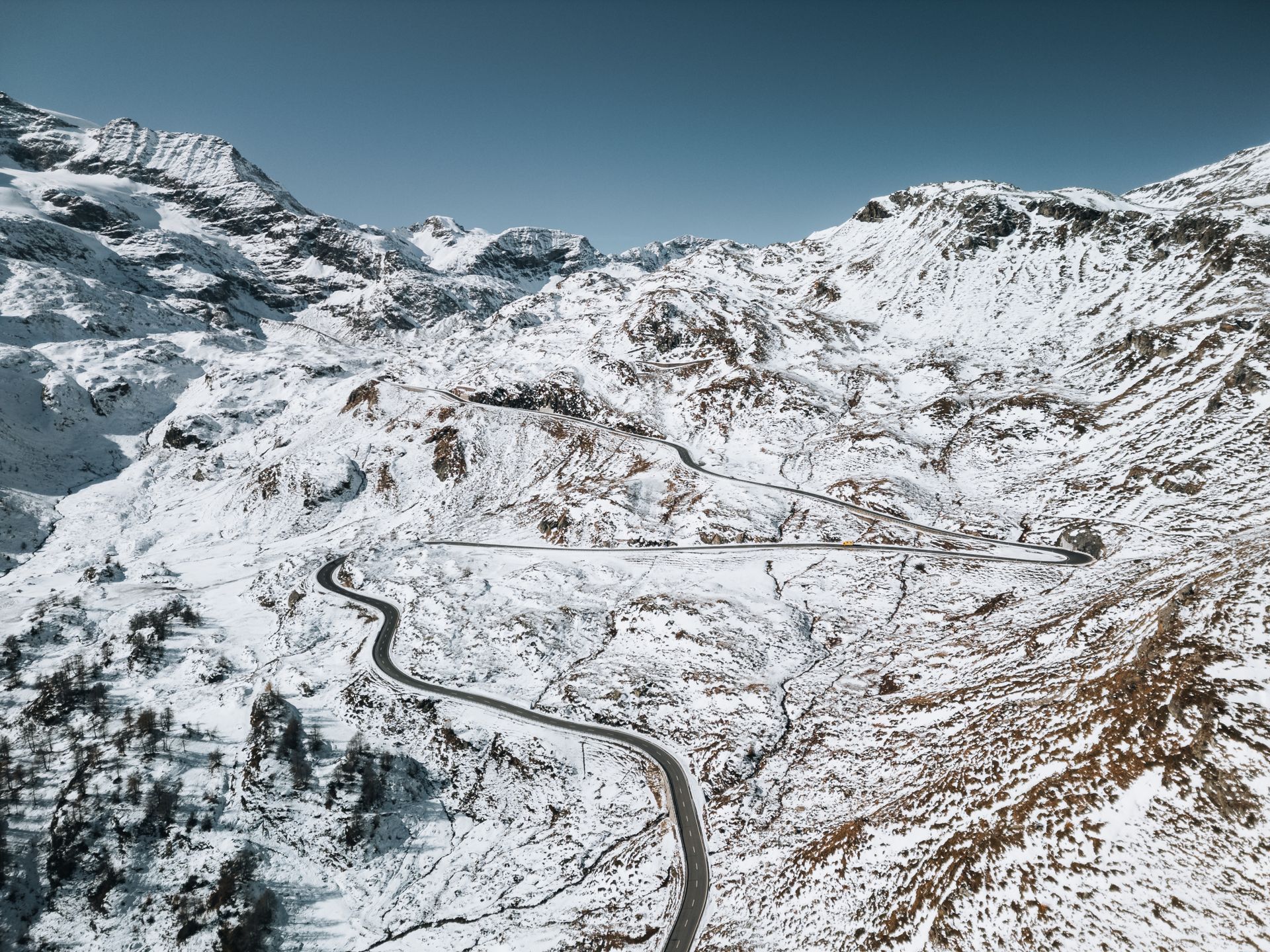
The Pamir Highway is one of the world's highest international roads, traversing the inland heart of Central Asia and rising to passes 4,655 metres above sea level that are open only a few months a year. The route runs from Hisor in Tajikistan, hugging the Afghan and Uzbek borders, to Osh in Kyrgyzstan, and includes 22 kilometres of effectively ungoverned no-man's-land between the two states where no formal border post stands.
The road was first planned in 1891 by Russian Lieutenant Colonel Bronislav Grombchevsky. He drafted a memorandum to convince Tsar Alexander III that a road across the Pamirs was the only way to counter Britain's northward push from India. It was part of the so-called Great Game: throughout the 19th century, Russia and the British Empire jockeyed bitterly for influence on the Tibetan, Afghan and Pamir borders of British India.
Construction began in 1912. Engineers tried to lay a modern road over the medieval merchant trail. The Pamirs did not surrender easily: local legend says the mountains exacted a heavy price from the engineers. "Not a single engineer or builder returned," goes a Tajik folk song. Modern asphalt was laid during the Soviet period from 1934 to 1940. The road's current name, "M41," comes from the Soviet highway numbering system.
The highest passes on the route include Akbaytal Pass (4,655 m) and Kyzyl-Art Pass (4,280 m). Air temperature at Akbaytal stays below minus 30 degrees Celsius for seven months of the year. For cyclists the season runs only from late June to mid-September. Oxygen at this altitude is roughly 60% of sea-level levels; unacclimatised travellers commonly experience symptoms of altitude sickness.
The road's most extraordinary feature is the gap that opens at the Tajik-Kyrgyz border. After the official border markings end, 22 kilometres pass without any formal checkpoint, customs office, gendarmerie tower or population transit register. The strip was not run as a Soviet-era checkpoint, and after independence neither state has prioritised its administration. Drivers periodically get stranded in storms in this section.
Users of the road today fall into three categories: local timber and wool merchants, Tajik-Pakistani caravans, and international cyclists and motorcyclists. Annual traffic is estimated at no more than 12,000 vehicles; for comparison, the roads through Turkey's Cilo mountains carry similar volumes weekly. Way-stations on the passes amount to three or four-tent caravanserais; the highest, on the shore of Karakul Lake, is the Saryash rest stop.
The geopolitics of the road have shifted in the post-Soviet era. In the early 2000s, China, under investment treaties with Tajikistan, repaired some sections; in 2014, a Chinese contractor relaid 18 kilometres around the Akbaytal Pass. Beijing's Belt and Road Initiative (BRI) proposed an additional connector through Tajikistan to Pakistan in 2023; the proposal is not yet under construction.
Ecologically, the road's surroundings have been under climate-change pressure in recent years. Pamir glaciers lost 18% of their volume between 2000 and 2024. Nomadic herders in the Bartang Valley near the road say pastures have shifted and old summer routes are now snow-free. The Tajik Academy of Sciences in 2025 forecast that of the Pamirs' 1,456 glaciers, 320 could disappear entirely within the next decade.
For international travellers, the road has become legendary. Lonely Planet's 2024 edition lists the Pamir Highway among "the world's most demanding motorbike routes." British traveller Adrian Bezzina became, in spring 2025, the first Maltese cyclist to complete the entire route; in his journal he wrote: "I crossed the 22 kilometres of no-man's-land and it was the quietest place I have ever known. Not a bird, not an engine; only my own breathing and the wind."
The road today is an example of how Soviet-inherited development infrastructure persists in contradictory ways. Tajikistan's and Kyrgyzstan's budgets are insufficient for its upkeep; Chinese infrastructure capital is competent but extracts a geopolitical price. The Great Game's legacy continues even in 2026 in the Pamir passes - this time as a competition between Russia, China and the United States for influence in Central Asia. However remote, the road remains part of the world's strategic map.